
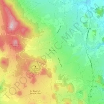
Cayres topographic map
Interactive map
Click on the map to display elevation.
About this map
Name: Cayres topographic map, elevation, terrain.
Average elevation: 3,727 ft
Minimum elevation: 3,114 ft
Maximum elevation: 4,675 ft
Other topographic maps
Click on a map to view its topography, its elevation and its terrain.
Le Puy-en-Velay
França > Auvergne-Rhône-Alpes > Haute-Loire
Le Puy-en-Velay, Haute-Loire, Auvergne-Rhône-Alpes, França metropolitana, 43000, França
Average elevation: 2,418 ft
Saint-Georges-Lagricol
França > Auvergne-Rhône-Alpes > Haute-Loire
Saint-Georges-Lagricol, Le Puy-en-Velay, Haute-Loire, Auvergne-Rhône-Alpes, França metropolitana, 43500, França
Average elevation: 2,881 ft
La Chaise-Dieu
França > Auvergne-Rhône-Alpes > Haute-Loire
La Chaise-Dieu, Brioude, Haute-Loire, Auvergne-Rhône-Alpes, França metropolitana, 43160, França
Average elevation: 3,337 ft