
Thank you for supporting this site ❤️
Make a donation
Make a donation
Gear up for your next adventure:
As an Amazon Associate, this site earns from qualifying purchases at no extra cost to you.
Kakachi topographic map
Click on the map to display elevation.
Thank you for supporting this site ❤️
Make a donation
Make a donation
Gear up for your next adventure:
As an Amazon Associate, this site earns from qualifying purchases at no extra cost to you.
About this map
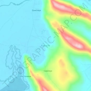
Name: Kakachi topographic map, elevation, terrain.
Location: Kakachi, Huancané, Province of Huancané, Puno, Peru (-15.26744 -69.81165 -15.22744 -69.77165)
Average elevation: 12,736 ft
Minimum elevation: 12,500 ft
Maximum elevation: 13,438 ft
Thank you for supporting this site ❤️
Make a donation
Make a donation
Gear up for your next adventure:
As an Amazon Associate, this site earns from qualifying purchases at no extra cost to you.