
Tocoy topographic map
Interactive map
Click on the map to display elevation.
About this map
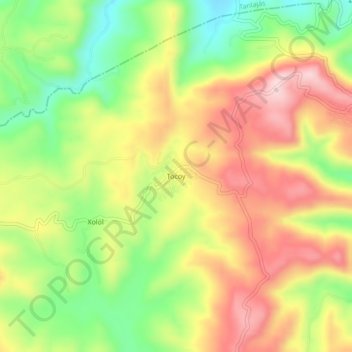
Name: Tocoy topographic map, elevation, terrain.
Location: Tocoy, San Antonio, San Luis Potosí, México (21.61932 -98.88982 21.65932 -98.84982)
Average elevation: 820 ft
Minimum elevation: 354 ft
Maximum elevation: 1,276 ft
Other topographic maps
Click on a map to view its topography, its elevation and its terrain.
Colonia Altamira
México > San Luis Potosí > San Antonio > Colonia Altamira
Colonia Altamira, San Antonio, San Luis Potosí, México
Average elevation: 732 ft