
Jungwon-gu topographic map
Interactive map
Click on the map to display elevation.
About this map
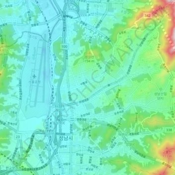
Name: Jungwon-gu topographic map, elevation, terrain.
Location: Jungwon-gu, Seongnam-si, Gyeonggi, South Korea (37.40543 127.11757 37.47481 127.19596)
Average elevation: 272 ft
Minimum elevation: 26 ft
Maximum elevation: 1,362 ft
Other topographic maps
Click on a map to view its topography, its elevation and its terrain.
Bundang-gu
Bundang-gu, Seongnam-si, Gyeonggi, South Korea
Average elevation: 482 ft