
Tosal de Malmarruy topographic map
Interactive map
Click on the map to display elevation.
About this map
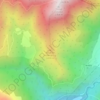
Name: Tosal de Malmarruy topographic map, elevation, terrain.
Location: Tosal de Malmarruy, Montanuy, Ribagorce, Huesca, Aragon, Espagne (42.55849 0.72867 42.55859 0.72877)
Average elevation: 5,469 ft
Minimum elevation: 3,642 ft
Maximum elevation: 7,697 ft
Other topographic maps
Click on a map to view its topography, its elevation and its terrain.
Vall de Salenques
Vall de Salenques, Camino a Mulleres, Montanuy, La Ribagorza, Huesca, Aragon, Espagne
Average elevation: 8,127 ft
Embalse de Llauset
Embalse de Llauset, GR-11.5, Montanuy, La Ribagorza, Huesca, Aragon, Espagne
Average elevation: 7,657 ft