
Make a donation
Gear up for your next adventure:
As an Amazon Associate, this site earns from qualifying purchases at no extra cost to you.
North Bergen topographic map
Click on the map to display elevation.
Gear up for your next adventure:
As an Amazon Associate, this site earns from qualifying purchases at no extra cost to you.
North Bergen
North Bergen has diverse geological features. Partially situated on the Hudson River, the Hudson Palisades rise from the waterfront, while the northern part of the town sits atop the plateau. The cuesta, or slope, on its west side makes North Bergen the city with the second-most hills per square mile in the United States after San Francisco, some of which are extremely steep. A rock formation along the slope (located at 40°48′27″N 74°01′05″W / 40.80750°N 74.01806°W / 40.80750; -74.01806 (Rock formation in North Bergen)) is composed of unusual serpentinite rock and made up of small rock cliffs. Because of this, it is one of the few undeveloped parts of North Bergen. Low-lying areas along the west side are part of the New Jersey Meadowlands. The unusual shape and diverse topography of North Bergen have created diverse historical and contemporary neighborhoods.
Make a donation
Gear up for your next adventure:
As an Amazon Associate, this site earns from qualifying purchases at no extra cost to you.
About this map
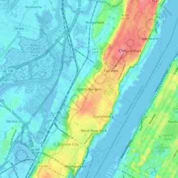
Name: North Bergen topographic map, elevation, terrain.
Average elevation: 72 ft
Minimum elevation: -16 ft
Maximum elevation: 335 ft
Make a donation
Gear up for your next adventure:
As an Amazon Associate, this site earns from qualifying purchases at no extra cost to you.