
Crew topographic map
Interactive map
Click on the map to display elevation.
About this map
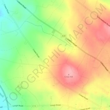
Name: Crew topographic map, elevation, terrain.
Location: Crew, Lisburn, County Antrim, Northern Ireland, United Kingdom (54.56363 -6.20799 54.58024 -6.16538)
Average elevation: 459 ft
Minimum elevation: 262 ft
Maximum elevation: 623 ft
Other topographic maps
Click on a map to view its topography, its elevation and its terrain.
Black Mountain
United Kingdom > Northern Ireland > Lisburn
Black Mountain, Lisburn, County Antrim, Northern Ireland, BT11 8BU, United Kingdom
Average elevation: 761 ft
Tonagh
United Kingdom > Northern Ireland > Lisburn
Tonagh, Lisburn, County Antrim, Northern Ireland, United Kingdom
Average elevation: 174 ft
Old Warren
United Kingdom > Northern Ireland > Lisburn
Old Warren, Lisburn, County Antrim, Northern Ireland, United Kingdom
Average elevation: 144 ft
Aghalislone
United Kingdom > Northern Ireland > Lisburn
Aghalislone, Lisburn, County Antrim, Northern Ireland, United Kingdom
Average elevation: 456 ft