
Quimbaya topographic map
Interactive map
Click on the map to display elevation.
About this map
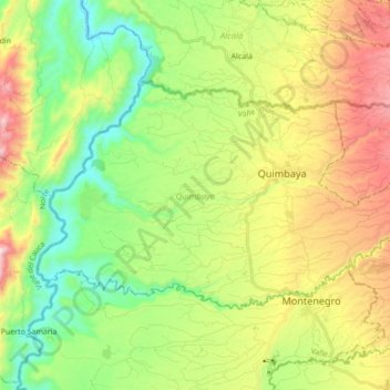
Name: Quimbaya topographic map, elevation, terrain.
Location: Quimbaya, Quindío, Colombia (4.56248 -75.87250 4.66357 -75.69941)
Average elevation: 4,029 ft
Minimum elevation: 3,068 ft
Maximum elevation: 5,495 ft
Other topographic maps
Click on a map to view its topography, its elevation and its terrain.
Las Alamos
Las Alamos, Génova, Cordillerana, Quindío, RAP Eje Cafetero, 632087, Colombia
Average elevation: 5,873 ft
Perímetro Urbano Armenia
Perímetro Urbano Armenia, Armenia, Capital, Quindío, RAP Eje Cafetero, Colombia
Average elevation: 4,859 ft