Geolocate

Brenham topographic map

Click on the map to display elevation.

About this map

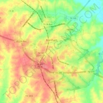
Name: Brenham topographic map, elevation, terrain.

Location: Brenham, Washington County, Texas, 77633, United States (30.11981 -96.43851 30.19663 -96.36008)

Average elevation: 322 ft

Minimum elevation: 197 ft

Maximum elevation: 423 ft

Washington County trails, hiking, mountain biking, running and outdoor activities

Other topographic maps

Click on a map to view its topography, its elevation and its terrain.

Washington

United States > Texas > Washington County

Average elevation: 220 ft

Chappell Hill

United States > Texas > Washington County

Average elevation: 272 ft

Independence

United States > Texas > Washington County

Average elevation: 348 ft

Chappell Hill

United States > Texas > Washington County

Average elevation: 272 ft

Independence

United States > Texas > Washington County

Average elevation: 348 ft

Chappell Hill

United States > Texas > Washington County

Average elevation: 272 ft

Whitman

United States > Texas > Washington County

Average elevation: 259 ft

Gear up for your next adventure:

🧭Hiking Compass - Precision compass for reliable navigation in the wilderness
🛰️Handheld GPS Units - Professional satellite navigators for precise backcountry mapping
🧤Tactile Hiking Gloves - Keep hands warm while operating GPS and smartphone screens
🧺Microfiber Travel Towels - Compact and fast-drying towels for trail use
🌄Hiking Binoculars - Compact binoculars for scenic views and trail spotting

As an Amazon Associate, this site earns from qualifying purchases at no extra cost to you.