
Make a donation
Gear up for your next adventure:
As an Amazon Associate, this site earns from qualifying purchases at no extra cost to you.
Ponteareas topographic map
Click on the map to display elevation.
Make a donation
Gear up for your next adventure:
As an Amazon Associate, this site earns from qualifying purchases at no extra cost to you.
Ponteareas
El municipio tiene una estructura territorial reticular definida por su ubicación en el valle del río Tea. El espacio central del valle es ocupado por el casco urbano, mientras un total de 23 parroquias o núcleos rurales se distribuyen en las laderas o en las vaguadas del propio valle. De norte a sur, por el espacio central, transcurre el río Tea, sobre cuyos márgenes se asienta una importante parte de la población del municipio. Limitando el valle y el propio término municipal se encuentran zonas montañosas, como son la sierra de Galleiro (745 metros) al noroeste, monte de la Picaraña (383 metros) al este, y monte Outeiro do Foxo (426 metros) al suroeste. La altitud oscila entre los 745 metros al noroeste (Sierra de Galleiro) y los 25 metros a orillas del río Tea. El pueblo se alza a 50 metros sobre el nivel del mar.
Make a donation
Gear up for your next adventure:
As an Amazon Associate, this site earns from qualifying purchases at no extra cost to you.
About this map
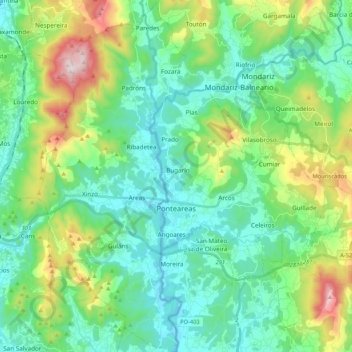
Name: Ponteareas topographic map, elevation, terrain.
Location: Ponteareas, Condado, Pontevedra, Galicia, España (42.11015 -8.58818 42.26681 -8.41595)
Average elevation: 630 ft
Minimum elevation: 33 ft
Maximum elevation: 2,415 ft
Make a donation
Gear up for your next adventure:
As an Amazon Associate, this site earns from qualifying purchases at no extra cost to you.
Other topographic maps
Click on a map to view its topography, its elevation and its terrain.
Make a donation
Gear up for your next adventure:
As an Amazon Associate, this site earns from qualifying purchases at no extra cost to you.