
Câineni topographic map
Interactive map
Click on the map to display elevation.
About this map
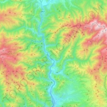
Name: Câineni topographic map, elevation, terrain.
Location: Câineni, Vâlcea, Romania (45.44009 24.11898 45.59085 24.48812)
Average elevation: 3,284 ft
Minimum elevation: 1,030 ft
Maximum elevation: 7,890 ft
Other topographic maps
Click on a map to view its topography, its elevation and its terrain.
Culmea Dragobăț
Culmea Dragobăț, Boișoara, Vâlcea, 247050, Romania
Average elevation: 3,865 ft
Râmnicu Vâlcea
Romania > Vâlcea > Râmnicu Vâlcea
Râmnicu Vâlcea, Vâlcea, 240140, Romania
Average elevation: 1,407 ft