
Le Bocq topographic map
Interactive map
Click on the map to display elevation.
About this map
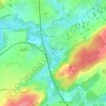
Name: Le Bocq topographic map, elevation, terrain.
Location: Le Bocq, Ciney, Dinant, Namur, Wallonie, 5360, Belgique (50.31806 5.06454 50.32590 5.07040)
Average elevation: 787 ft
Minimum elevation: 686 ft
Maximum elevation: 961 ft
Other topographic maps
Click on a map to view its topography, its elevation and its terrain.
Le Leignon
Le Leignon, Ciney, Namur, Wallonie, 5590, Belgique
Average elevation: 906 ft