
ग्याचुङ काङ 格重康峰 Gyachung Kang topographic map
Interactive map
Click on the map to display elevation.
About this map
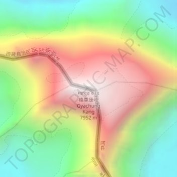
Name: ग्याचुङ काङ 格重康峰 Gyachung Kang topographic map, elevation, terrain.
Average elevation: 22,986 ft
Minimum elevation: 20,433 ft
Maximum elevation: 26,024 ft
Other topographic maps
Click on a map to view its topography, its elevation and its terrain.
Lhotse Shar
Nepal > Región de desarrollo Este > Khumjung
Lhotse Shar, Khumjung, सोलुखुम्बु, सगरमाथा अञ्चल, Región de desarrollo Este, Nepal
Average elevation: 23,468 ft
Himalayas
Nepal > Región de desarrollo Este > Khumjung
Himalayas, Khumjung, सोलुखुम्बु, सगरमाथा अञ्चल, Región de desarrollo Este, Nepal
Average elevation: 24,787 ft