
Marigot topographic map
Interactive map
Click on the map to display elevation.
About this map
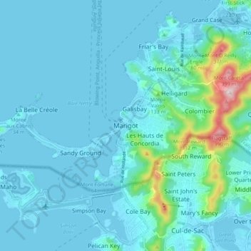
Name: Marigot topographic map, elevation, terrain.
Location: Marigot, Saint-Martin (France), 97150, France (18.02685 -63.12489 18.10685 -63.04489)
Average elevation: 144 ft
Minimum elevation: -7 ft
Maximum elevation: 1,358 ft
Other topographic maps
Click on a map to view its topography, its elevation and its terrain.
Saint-Martin (France)
France > Saint-Martin (France) > Saint-Martin (France)
Saint-Martin (France), 97150, France
Average elevation: 49 ft