
River Head topographic map
Interactive map
Click on the map to display elevation.
About this map
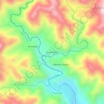
Name: River Head topographic map, elevation, terrain.
Location: River Head, Saint Thomas, Surrey County, Jamaica (17.97304 -76.64148 18.01304 -76.60148)
Average elevation: 1,552 ft
Minimum elevation: 610 ft
Maximum elevation: 2,651 ft
Other topographic maps
Click on a map to view its topography, its elevation and its terrain.
Suffolk Park
Suffolk Park, Rowlandsfield, Saint Thomas, Surrey County, Jamaica
Average elevation: 476 ft
York
York, Seaforth, Saint Thomas, Surrey County, Jamaica
Average elevation: 394 ft
Farm Hill
Farm Hill, Saint Thomas, Surrey County, Jamaica
Average elevation: 3,353 ft
Eleven Mile
Eleven Mile, Saint Thomas, Surrey County, Jamaica
Average elevation: 436 ft
Morant Bay
Morant Bay, Saint Thomas, Surrey County, Jamaica
Average elevation: 75 ft