
Wonga Park topographic map
Interactive map
Click on the map to display elevation.
About this map
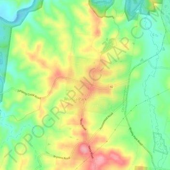
Name: Wonga Park topographic map, elevation, terrain.
Location: Wonga Park, City of Manningham, Victoria, 3115, Australia (-37.75568 145.24980 -37.71568 145.28980)
Average elevation: 312 ft
Minimum elevation: 121 ft
Maximum elevation: 558 ft
Other topographic maps
Click on a map to view its topography, its elevation and its terrain.
Mount Lofty Park
Australia > Victoria > Melbourne > Wonga Park
Mount Lofty Park, Bend of Islands, Melbourne, Shire of Nillumbik, Victoria, Australia
Average elevation: 292 ft