
Sidi Ladjel topographic map
Interactive map
Click on the map to display elevation.
About this map
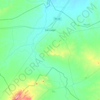
Name: Sidi Ladjel topographic map, elevation, terrain.
Location: Sidi Ladjel, Daïra Sidi Ladjel, Djelfa, 17215, Algérie (35.24391 2.31322 35.52046 2.60667)
Average elevation: 2,428 ft
Minimum elevation: 2,182 ft
Maximum elevation: 3,665 ft
Other topographic maps
Click on a map to view its topography, its elevation and its terrain.
Hassi Fedoul
Algérie > Djelfa > Daïra Sidi Ladjel
Hassi Fedoul, Daïra Sidi Ladjel, Djelfa, Algérie
Average elevation: 2,618 ft