
Syzran topographic map
Interactive map
Click on the map to display elevation.
About this map
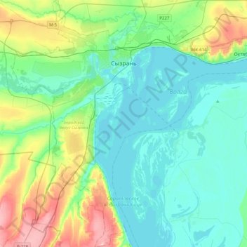
Name: Syzran topographic map, elevation, terrain.
Location: Syzran, Samara Oblast, Volga Federal District, Russia (52.97711 48.29384 53.21606 48.58670)
Average elevation: 233 ft
Minimum elevation: 75 ft
Maximum elevation: 768 ft
Other topographic maps
Click on a map to view its topography, its elevation and its terrain.
Saratov reservoir
Russia > Samara Oblast > Syzran
Saratov reservoir, Комплексная улица, Syzran, Samara Oblast, Volga Federal District, 446008, Russia
Average elevation: 259 ft