
Maha Sarakham topographic map
Interactive map
Click on the map to display elevation.
About this map
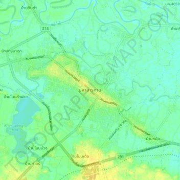
Name: Maha Sarakham topographic map, elevation, terrain.
Location: Maha Sarakham, แวงน่าง, Maha Sarakham, Thaïlande (16.14809 103.25873 16.22809 103.33873)
Average elevation: 479 ft
Minimum elevation: 453 ft
Maximum elevation: 522 ft
Other topographic maps
Click on a map to view its topography, its elevation and its terrain.
บ้านเมืองเสือ
บ้านเมืองเสือ, Maha Sarakham, Thaïlande
Average elevation: 446 ft