
Lower Holker topographic map
Interactive map
Click on the map to display elevation.
About this map
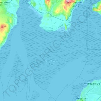
Name: Lower Holker topographic map, elevation, terrain.
Average elevation: 20 ft
Minimum elevation: 0 ft
Maximum elevation: 614 ft
Other topographic maps
Click on a map to view its topography, its elevation and its terrain.
Seathwaite Tarn
Vereinigtes Königreich > England > South Lakeland
Seathwaite Tarn, Walna Scar Road, Dunnerdale-with-Seathwaite, South Lakeland, Cumbria, Nordwestengland, England, LA20 6EE, Vereinigtes Königreich
Average elevation: 1,496 ft
Kentmere
Vereinigtes Königreich > England > South Lakeland
Kentmere, South Lakeland, Cumbria, Nordwestengland, England, Vereinigtes Königreich
Average elevation: 1,322 ft