
Aguiló topographic map
Interactive map
Click on the map to display elevation.
About this map
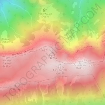
Name: Aguiló topographic map, elevation, terrain.
Location: Aguiló, Bagà, Berguedà, Barcelona, Cataluña, España (42.28622 1.71679 42.28632 1.71689)
Average elevation: 7,116 ft
Minimum elevation: 5,066 ft
Maximum elevation: 8,346 ft
Other topographic maps
Click on a map to view its topography, its elevation and its terrain.
Puigllançada
Puigllançada, Bagà, Berguedà, Barcelona, Cataluña, 177537, España
Average elevation: 6,896 ft