
Landéda topographic map
Interactive map
Click on the map to display elevation.
About this map
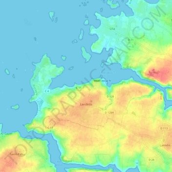
Name: Landéda topographic map, elevation, terrain.
Average elevation: 62 ft
Minimum elevation: -7 ft
Maximum elevation: 213 ft
Other topographic maps
Click on a map to view its topography, its elevation and its terrain.
Cité Pen ar C'hloz
França > Bretanha > Finistère > Saint-Pol-de-Léon
Cité Pen ar C'hloz, Saint-Pol-de-Léon, Morlaix, Finistère, Bretanha, França metropolitana, 29250, França
Average elevation: 82 ft