
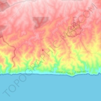
Tunkalilla topographic map
Interactive map
Click on the map to display elevation.
About this map
Name: Tunkalilla topographic map, elevation, terrain.
Average elevation: 594 ft
Minimum elevation: 0 ft
Maximum elevation: 1,247 ft
Other topographic maps
Click on a map to view its topography, its elevation and its terrain.
Normanville
Australia > South Australia > The District Council of Yankalilla
Normanville, The District Council of Yankalilla, South Australia, 5204, Australia
Average elevation: 210 ft
Yankalilla
Australia > South Australia > The District Council of Yankalilla
Yankalilla, The District Council of Yankalilla, South Australia, 5203, Australia
Average elevation: 341 ft
The District Council of Yankalilla
Australia > South Australia > The District Council of Yankalilla
The District Council of Yankalilla, South Australia, Australia
Average elevation: 390 ft