
Üssers Barrhorn Nord topographic map
Interactive map
Click on the map to display elevation.
About this map
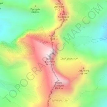
Name: Üssers Barrhorn Nord topographic map, elevation, terrain.
Location: Üssers Barrhorn Nord, St. Niklaus, Visp, Vallese, 3924, Svizzera (46.15640 7.73539 46.15650 7.73549)
Average elevation: 10,072 ft
Minimum elevation: 8,720 ft
Maximum elevation: 11,804 ft
Other topographic maps
Click on a map to view its topography, its elevation and its terrain.
Stecknadelhorn
Svizzera > Vallese > St. Niklaus
Stecknadelhorn, St. Niklaus, Visp, Vallese, 3924, Svizzera
Average elevation: 12,316 ft
Dürrenhorn
Svizzera > Vallese > St. Niklaus
Dürrenhorn, St. Niklaus, Visp, Vallese, 3924, Svizzera
Average elevation: 11,565 ft