
Thank you for supporting this site ❤️
Make a donation
Make a donation
Gear up for your next adventure:
As an Amazon Associate, this site earns from qualifying purchases at no extra cost to you.
Wagrain topographic map
Click on the map to display elevation.
Thank you for supporting this site ❤️
Make a donation
Make a donation
Gear up for your next adventure:
As an Amazon Associate, this site earns from qualifying purchases at no extra cost to you.
About this map
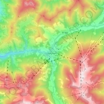
Name: Wagrain topographic map, elevation, terrain.
Location: Wagrain, Bezirk St. Johann im Pongau, Salzburg, 5602, Austria (47.28430 13.25732 47.38489 13.36522)
Average elevation: 4,265 ft
Minimum elevation: 2,310 ft
Maximum elevation: 6,568 ft
Thank you for supporting this site ❤️
Make a donation
Make a donation
Gear up for your next adventure:
As an Amazon Associate, this site earns from qualifying purchases at no extra cost to you.