
Make a donation
Gear up for your next adventure:
As an Amazon Associate, this site earns from qualifying purchases at no extra cost to you.
Billère topographic map
Click on the map to display elevation.
Make a donation
Gear up for your next adventure:
As an Amazon Associate, this site earns from qualifying purchases at no extra cost to you.
About this map
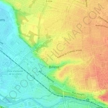
Name: Billère topographic map, elevation, terrain.
Average elevation: 623 ft
Minimum elevation: 535 ft
Maximum elevation: 712 ft
Make a donation
Gear up for your next adventure:
As an Amazon Associate, this site earns from qualifying purchases at no extra cost to you.
Other topographic maps
Click on a map to view its topography, its elevation and its terrain.
Make a donation
Gear up for your next adventure:
As an Amazon Associate, this site earns from qualifying purchases at no extra cost to you.
Château-Observatoire Abbadia
France > Nouvelle-Aquitaine > Pyrénées-Atlantiques > Hendaye > Sopite
Average elevation: 82 ft
Make a donation
Gear up for your next adventure:
As an Amazon Associate, this site earns from qualifying purchases at no extra cost to you.
Izpegi
France > Nouvelle-Aquitaine > Pyrénées-Atlantiques > Saint-Étienne-de-Baïgorry
Average elevation: 2,073 ft
Pic d'Orisson / Harburu
France > Nouvelle-Aquitaine > Pyrénées-Atlantiques > Saint-Michel
Average elevation: 2,680 ft
Pic d'Orisson / Harburu
France > Nouvelle-Aquitaine > Pyrénées-Atlantiques > Saint-Michel
Average elevation: 2,680 ft
Make a donation
Gear up for your next adventure:
As an Amazon Associate, this site earns from qualifying purchases at no extra cost to you.
Larroinea
France > Nouvelle-Aquitaine > Pyrénées-Atlantiques > Saint-Jean-Pied-de-Port
Average elevation: 669 ft
Agerreko Larrea
France > Nouvelle-Aquitaine > Pyrénées-Atlantiques > Mouguerre
Average elevation: 128 ft
Larroinea
France > Nouvelle-Aquitaine > Pyrénées-Atlantiques > Saint-Jean-Pied-de-Port
Average elevation: 669 ft
Make a donation
Gear up for your next adventure:
As an Amazon Associate, this site earns from qualifying purchases at no extra cost to you.