
دهستان کذاب topographic map
Interactive map
Click on the map to display elevation.
About this map
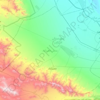
Name: دهستان کذاب topographic map, elevation, terrain.
Location: دهستان کذاب, بخش خضرآباد, Ashkezar County, Yazd Province, Iran (31.75655 53.70224 32.13434 54.21195)
Average elevation: 5,512 ft
Minimum elevation: 3,593 ft
Maximum elevation: 11,020 ft
Other topographic maps
Click on a map to view its topography, its elevation and its terrain.
Shamsi
Iran > Yazd Province > Ashkezar County > دهستان رستاق
Shamsi, دهستان رستاق, بخش مرکزی اشکذر, Ashkezar County, Yazd Province, Iran
Average elevation: 3,734 ft