
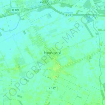
Neuscharrel topographic map
Interactive map
Click on the map to display elevation.
About this map
Name: Neuscharrel topographic map, elevation, terrain.
Average elevation: 26 ft
Minimum elevation: 13 ft
Maximum elevation: 46 ft
Ahrensdorf | Altenoythe | Augustendorf | Edewechterdamm | Ellerbrock | Friesoythe | Gehlenberg | Heinfelde | Kampe | Kamperfehn | Markhausen | Mehrenkamp | Neuscharrel | Neuvrees | Pehmertange | Schlingshöhe | Schwaneburg | Schwaneburgermoor | Thüle
Other topographic maps
Click on a map to view its topography, its elevation and its terrain.
Edewechterdamm
Deutschland > Niedersachsen > Landkreis Cloppenburg > Friesoythe
Edewechterdamm, Friesoythe, Landkreis Cloppenburg, Niedersachsen, Deutschland
Average elevation: 23 ft
Pirgo
Deutschland > Niedersachsen > Landkreis Cloppenburg > Friesoythe > Altenoythe
Pirgo, Altenoythe, Friesoythe, Landkreis Cloppenburg, Niedersachsen, 26169, Deutschland
Average elevation: 26 ft
Mittelsten Thüle
Deutschland > Niedersachsen > Landkreis Cloppenburg > Friesoythe > Mittelsten Thüle
Mittelsten Thüle, Friesoythe, Landkreis Cloppenburg, Niedersachsen, 26169, Deutschland
Average elevation: 59 ft
Neuvrees
Deutschland > Niedersachsen > Landkreis Cloppenburg > Friesoythe > Neuvrees
Neuvrees, Friesoythe, Landkreis Cloppenburg, Niedersachsen, 26169, Deutschland
Average elevation: 46 ft
Altenoythe
Deutschland > Niedersachsen > Landkreis Cloppenburg > Friesoythe > Altenoythe
Altenoythe, Friesoythe, Landkreis Cloppenburg, Niedersachsen, 26169, Deutschland
Average elevation: 30 ft