Geolocate

Murano topographic map

Click on the map to display elevation.

About this map

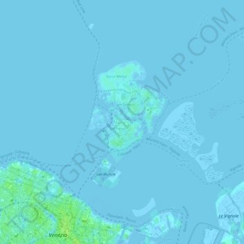
Name: Murano topographic map, elevation, terrain.

Location: Murano, Venice, Venezia, Veneto, 30141, Italy (45.43550 12.33110 45.47550 12.37110)

Average elevation: 3 ft

Minimum elevation: -30 ft

Maximum elevation: 36 ft

Other topographic maps

Click on a map to view its topography, its elevation and its terrain.

Murano

Italy > Veneto > Venezia > Venice > Murano

Average elevation: 0 ft

Canal Grande

Italy > Veneto > Venezia > Venice > Lido

Average elevation: 7 ft

Burano

Italy > Veneto > Venezia > Venice > Burano

Average elevation: 0 ft

Sant'Erasmo

Italy > Veneto > Venezia > Venice > Sant'Erasmo

Average elevation: 0 ft

Gear up for your next adventure:

🧼Biodegradable Camping Soap - Eco‑friendly soap for outdoor hygiene
🧢Sun Protection Hats - Wide-brimmed and UPF-rated hats for high-altitude sun safety
🔥Plasma Lighters - Windproof lighters that work in any weather condition
🥩Freeze-Dried Meals - Nutritious and lightweight food for remote expeditions
🌎3D Topographic Globes - Raised relief globes for a tactile understanding of geography

As an Amazon Associate, this site earns from qualifying purchases at no extra cost to you.