
Prey Nob District topographic map
Interactive map
Click on the map to display elevation.
About this map
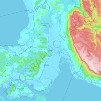
Name: Prey Nob District topographic map, elevation, terrain.
Location: Prey Nob District, Khaet Preah Sihanouk, Cambodia (10.48706 103.55943 10.95303 103.96751)
Average elevation: 502 ft
Minimum elevation: -10 ft
Maximum elevation: 3,501 ft
Other topographic maps
Click on a map to view its topography, its elevation and its terrain.
Koh Rong
Cambodia > Khaet Preah Sihanouk > Sok San Village
Koh Rong, Sok San Village, Khaet Preah Sihanouk, Cambodia
Average elevation: 82 ft
Prek Moat Peam
Cambodia > Khaet Preah Sihanouk > Prey Nob District
Prek Moat Peam, Prey Nob District, Khaet Preah Sihanouk, SANGKAT 4, Cambodia
Average elevation: 89 ft
Sihanoukville
Cambodia > Khaet Preah Sihanouk > Krong Preah Sihanouk
Sihanoukville, Krong Preah Sihanouk, Khaet Preah Sihanouk, 180000, Cambodia
Average elevation: 46 ft