
Estoul topographic map
Interactive map
Click on the map to display elevation.
About this map
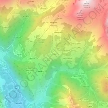
Name: Estoul topographic map, elevation, terrain.
Location: Estoul, Brusson, Vallée d'Aoste, 11022, Italie (45.73799 7.74505 45.77799 7.78505)
Average elevation: 6,004 ft
Minimum elevation: 3,707 ft
Maximum elevation: 9,049 ft
Other topographic maps
Click on a map to view its topography, its elevation and its terrain.
Delaz Inferiore
Italie > Vallée d'Aoste > Brusson
Delaz Inferiore, Brusson, Vallée d'Aoste, 11022, Italie
Average elevation: 5,558 ft
Graines
Italie > Vallée d'Aoste > Brusson
Graines, Brusson, Vallée d'Aoste, 11022, Italie
Average elevation: 5,243 ft
La Croix
Italie > Vallée d'Aoste > Brusson > La Croix
La Croix, Brusson, Vallée d'Aoste, 11022, Italie
Average elevation: 5,614 ft
Murassaz
Italie > Vallée d'Aoste > Brusson
Murassaz, Brusson, Vallée d'Aoste, 11025, Italie
Average elevation: 6,614 ft