
Mangrove Mountain topographic map
Interactive map
Click on the map to display elevation.
About this map
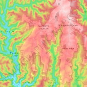
Name: Mangrove Mountain topographic map, elevation, terrain.
Average elevation: 636 ft
Minimum elevation: -3 ft
Maximum elevation: 1,155 ft
Other topographic maps
Click on a map to view its topography, its elevation and its terrain.
Kincumber
Australia > New South Wales > Gosford
Kincumber, Gosford, Central Coast Council, New South Wales, 2251, Australia
Average elevation: 121 ft
Bateau Bay
Australia > New South Wales > Gosford
Bateau Bay, Gosford, Central Coast Council, New South Wales, 2261, Australia
Average elevation: 52 ft
Tuggerawong
Australia > New South Wales > Gosford
Tuggerawong, Gosford, Central Coast Council, New South Wales, 2259, Australia
Average elevation: 10 ft
Wagstaffe
Australia > New South Wales > Gosford
Wagstaffe, Gosford, Central Coast Council, New South Wales, 2257, Australia
Average elevation: 56 ft
Wyong River
Australia > New South Wales > Gosford
Wyong River, Gosford, Central Coast Council, New South Wales, Australia
Average elevation: 574 ft
Lake Macquarie State Conservation Area
Australia > New South Wales > Gosford
Lake Macquarie State Conservation Area, Kanangra Drive, Crangan Bay, Gosford, Central Coast Council, New South Wales, 2259, Australia
Average elevation: 52 ft