
Zoutkamp topographic map
Interactive map
Click on the map to display elevation.
About this map
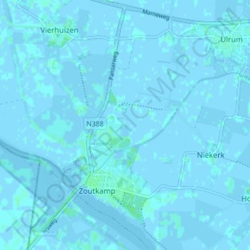
Name: Zoutkamp topographic map, elevation, terrain.
Location: Zoutkamp, Het Hogeland, Groningen, Nederland (53.32812 6.26018 53.36501 6.31852)
Average elevation: 0 ft
Minimum elevation: -23 ft
Maximum elevation: 16 ft
Other topographic maps
Click on a map to view its topography, its elevation and its terrain.
Eenrum
Nederland > Groningen > Het Hogeland
Eenrum, Het Hogeland, Groningen, Nederland
Average elevation: 0 ft
Lauwersoog
Nederland > Groningen > Het Hogeland
Lauwersoog, Het Hogeland, Groningen, Nederland
Average elevation: -3 ft