
La Junquera topographic map
Interactive map
Click on the map to display elevation.
About this map
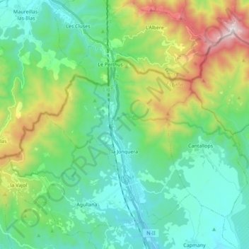
Name: La Junquera topographic map, elevation, terrain.
Location: La Junquera, Alto Ampurdán, Gerona, Cataluña, España (42.38615 2.81773 42.48213 2.98820)
Average elevation: 1,230 ft
Minimum elevation: 220 ft
Maximum elevation: 4,081 ft
Other topographic maps
Click on a map to view its topography, its elevation and its terrain.
Paratge Natural d'Interès Nacional del massís de l'Albera
España > Cataluña > La Junquera
Paratge Natural d'Interès Nacional del massís de l'Albera, camí de Puig Neulós, La Junquera, Alto Ampurdán, Gerona, Cataluña, 17708, España
Average elevation: 1,407 ft