
Wayai topographic map
Interactive map
Click on the map to display elevation.
About this map
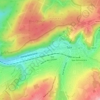
Name: Wayai topographic map, elevation, terrain.
Location: Wayai, Spa, Verviers, Liège, Wallonie, 4900, Belgique (50.49112 5.85456 50.49143 5.85463)
Average elevation: 997 ft
Minimum elevation: 732 ft
Maximum elevation: 1,253 ft
Other topographic maps
Click on a map to view its topography, its elevation and its terrain.
Domaine de Bérinzenne
Domaine de Bérinzenne, Coupe-feu du Tir, Spa, Verviers, Liège, Wallonie, 4900, Belgique
Average elevation: 1,690 ft
Lac de Warfaaz
Belgique > Wallonie > Spa > Jalhay
Lac de Warfaaz, Route du Lac de Warfa, Jalhay, Liège, Wallonie, 4845, Belgique
Average elevation: 1,102 ft
La Picherotte
La Picherotte, Spa, Verviers, Liège, Wallonie, 4900, Belgique
Average elevation: 1,227 ft