
宁洱哈尼族彝族自治县 topographic map
Interactive map
Click on the map to display elevation.
About this map
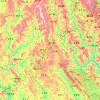
Name: 宁洱哈尼族彝族自治县 topographic map, elevation, terrain.
Location: 宁洱哈尼族彝族自治县, 普洱市 (Pu'er), Yunnan, 665000, China (22.42198 100.50073 23.70198 101.78073)
Average elevation: 4,436 ft
Minimum elevation: 1,706 ft
Maximum elevation: 9,196 ft