
Make a donation
Gear up for your next adventure:
As an Amazon Associate, this site earns from qualifying purchases at no extra cost to you.
León (Municipio) topographic map
Click on the map to display elevation.
Make a donation
Gear up for your next adventure:
As an Amazon Associate, this site earns from qualifying purchases at no extra cost to you.
About this map
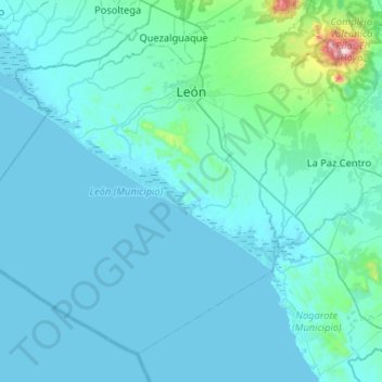
Name: León (Municipio) topographic map, elevation, terrain.
Location: León (Municipio), León, 21000, Nicaragua (12.08352 -87.19773 12.52085 -86.67567)
Average elevation: 200 ft
Minimum elevation: -3 ft
Maximum elevation: 3,494 ft
Make a donation
Gear up for your next adventure:
As an Amazon Associate, this site earns from qualifying purchases at no extra cost to you.
Other topographic maps
Click on a map to view its topography, its elevation and its terrain.
Telica volcano
Telica became active in August 1999. An eruption produced ash-fall, and on 18 August a lava lake was observed in the summit crater. The ash eruptions continued until February 2000 and declined afterwards. From 9 January to February 2007, small ash eruptions produced ash clouds reaching altitudes of 4900 ft…
Average elevation: 2,159 ft
Make a donation
Gear up for your next adventure:
As an Amazon Associate, this site earns from qualifying purchases at no extra cost to you.
Make a donation
Gear up for your next adventure:
As an Amazon Associate, this site earns from qualifying purchases at no extra cost to you.