
Imouzzer Kandar topographic map
Interactive map
Click on the map to display elevation.
About this map
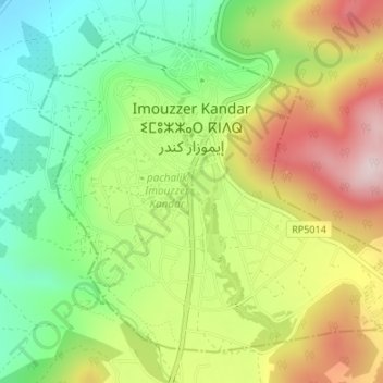
Name: Imouzzer Kandar topographic map, elevation, terrain.
Average elevation: 4,419 ft
Minimum elevation: 3,839 ft
Maximum elevation: 5,171 ft
Other topographic maps
Click on a map to view its topography, its elevation and its terrain.
Cascade d'Immouzer Kandar (temporaire)
Maroc > pachalik Imouzzer Kandar > Imouzzer Kandar
Cascade d'Immouzer Kandar (temporaire), Imouzzer Kandar, pachalik Imouzzer Kandar, Province de Sefrou, Fès-Meknès, 31252, Maroc
Average elevation: 4,459 ft