
Pech Cabanel topographic map
Interactive map
Click on the map to display elevation.
About this map
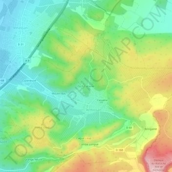
Name: Pech Cabanel topographic map, elevation, terrain.
Average elevation: 259 ft
Minimum elevation: 7 ft
Maximum elevation: 682 ft
Other topographic maps
Click on a map to view its topography, its elevation and its terrain.
Bringairet
France > Occitanie > Aude > Armissan
Bringairet, Armissan, Narbonne, Aude, Occitanie, France métropolitaine, 11110, France
Average elevation: 384 ft
La Ricarde
France > Occitanie > Aude > Armissan
La Ricarde, Armissan, Narbonne, Aude, Occitanie, France métropolitaine, 11110, France
Average elevation: 249 ft
Grange Neuve
France > Occitanie > Aude > Armissan > Grange Neuve
Grange Neuve, Armissan, Narbonne, Aude, Occitanie, France métropolitaine, 11110, France
Average elevation: 249 ft