
Lääneranna vald topographic map
Interactive map
Click on the map to display elevation.
About this map
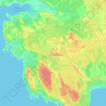
Name: Lääneranna vald topographic map, elevation, terrain.
Location: Lääneranna vald, Kreis Pernau, Estland (58.32906 23.39964 58.77436 24.35026)
Average elevation: 39 ft
Minimum elevation: 0 ft
Maximum elevation: 144 ft
Other topographic maps
Click on a map to view its topography, its elevation and its terrain.
Maade küla
Maade küla, Lääneranna vald, Kreis Pernau, 88218, Estland
Average elevation: 43 ft