Geolocate

Senafe topographic map

Click on the map to display elevation.

About this map

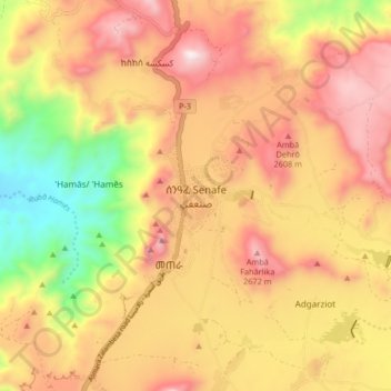
Name: Senafe topographic map, elevation, terrain.

Location: Senafe, Debub Region, Eritrea (14.66176 39.38438 14.74176 39.46438)

Average elevation: 7,769 ft

Minimum elevation: 6,066 ft

Maximum elevation: 9,085 ft

Other topographic maps

Click on a map to view its topography, its elevation and its terrain.

Adi halo

Eritrea > Debub Region

Average elevation: 6,417 ft

Mereb river

Eritrea > Debub Region

Average elevation: 4,646 ft

Mereb river ሩባ መረብ

Eritrea > Debub Region

Average elevation: 4,774 ft

Ma'ereba

Eritrea > Debub Region

Average elevation: 6,890 ft

Mereb river

Eritrea > Debub Region

Average elevation: 4,892 ft

Gear up for your next adventure:

🪶Camp Gear Gift Set - Perfect gift bundle for outdoor fans
🍳Camping Cook Set - Complete cookware for outdoor meals
☀️Outdoor Sunscreen - High protection sunscreen for outdoor activities
🧯Portable Fire Pit - Compact fire pit for camping spots
💧Water Purification System - Clean water on the trail with reliable purifiers

As an Amazon Associate, this site earns from qualifying purchases at no extra cost to you.