
Hobart topographic map
Interactive map
Click on the map to display elevation.
About this map
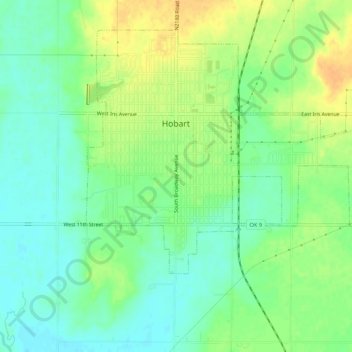
Name: Hobart topographic map, elevation, terrain.
Location: Hobart, Kiowa County, Oklahoma, 73651, United States (35.00359 -99.10957 35.03978 -99.05635)
Average elevation: 1,542 ft
Minimum elevation: 1,496 ft
Maximum elevation: 1,604 ft
Other topographic maps
Click on a map to view its topography, its elevation and its terrain.
Mountain View
United States > Oklahoma > Kiowa County
Mountain View, Kiowa County, Oklahoma, United States
Average elevation: 1,342 ft
Lone Wolf
United States > Oklahoma > Kiowa County
Lone Wolf, Kiowa County, Oklahoma, United States
Average elevation: 1,575 ft
Gotebo
United States > Oklahoma > Kiowa County
Gotebo, Kiowa County, Oklahoma, United States
Average elevation: 1,430 ft