
Pécs topographic map
Click on the map to display elevation.
Pécs
Pécs is bordered by plains to the south (elevation 120–130 m), while the Mecsek mountains rise up to elevations of 400–600 meters behind the city. Jakab-hill, located in the western Mecsek, is 592 m (1942 ft) tall, Tubes, straight above Pécs, is 612 m (2008 ft) tall, and Misina is 535 m (1755 ft) tall. Higher parts of the city climb up to 200–250 m (656 to 820 ft), mainly Pécsbánya, Szabolcsfalu, Vasas and Somogy. Woody areas generally start from elevations of about 300 m (984 ft). The Mecsek hills are marked by numerous valleys which play a key role in ameliorating the climate of the city in the absence of lakes and rivers. Waters coming down from the Mecsek hills flow into the Pécsi stream under the east–west rail road leading them eventually to the Danube.
About this map
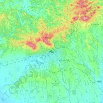
Name: Pécs topographic map, elevation, terrain.
Average elevation: 689 ft
Minimum elevation: 325 ft
Maximum elevation: 2,198 ft