
Make a donation
Gear up for your next adventure:
As an Amazon Associate, this site earns from qualifying purchases at no extra cost to you.
Gravatá topographic map
Click on the map to display elevation.
Make a donation
Gear up for your next adventure:
As an Amazon Associate, this site earns from qualifying purchases at no extra cost to you.
Gravatá
Gravatá is located at 08°12′04″S 35°33′53″W / 8.20111°S 35.56472°W / -8.20111; -35.56472. The average altitude is 447 metres (1,467 ft). The area of Gravatá is 491.53 km2 (189.78 sq mi). It is known for a pleasant climate (annual medium temperature 18 °C or 64.4 °F) and its charming houses with an Alpine architecture; it is placed in the rural countryside of Pernambuco (Agreste Pernambucano). Located in the rural district of the valley of Ipojuca (Vale do Ipojuca), a transition area between the Forest and the Rural Area, in the region formerly known the Borborema Plateau, nowadays called Serra das Russas (Russians' Mountain); have this name because of some blond and red haired people who live in the area (Dutch descendants, common in this region) who in this part of Brazil were known as Russians; it is part of the basin Capibaribe. Being an important regional centre town, it is linked to Recife by a federal highway (BR-232), which passes also Vitória de Santo Antão and Jaboatão dos Guararapes.
Make a donation
Gear up for your next adventure:
As an Amazon Associate, this site earns from qualifying purchases at no extra cost to you.
About this map
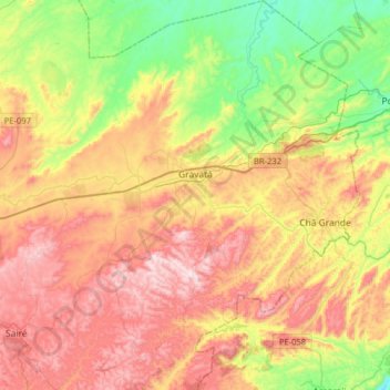
Name: Gravatá topographic map, elevation, terrain.
Average elevation: 1,470 ft
Minimum elevation: 413 ft
Maximum elevation: 2,661 ft
Make a donation
Gear up for your next adventure:
As an Amazon Associate, this site earns from qualifying purchases at no extra cost to you.
Other topographic maps
Click on a map to view its topography, its elevation and its terrain.
Praça Farias Neves
Brazil > Pernambuco > Região Metropolitana do Recife > Recife
Average elevation: 72 ft
Make a donation
Gear up for your next adventure:
As an Amazon Associate, this site earns from qualifying purchases at no extra cost to you.
Ana de Alburquerque
Brazil > Pernambuco > Região Metropolitana do Recife > Igarassu
Average elevation: 56 ft
Boa Paz
Brazil > Pernambuco > Região Administrativa Integrada de Desenvolvimento do Polo Petrolina e Juazeiro > Petrolina
Average elevation: 1,243 ft
Fernando de Noronha
Fernando de Noronha (Portuguese pronunciation: [feʁˈnɐ̃du dʒi noˈɾoɲɐ]) is an archipelago in the Atlantic Ocean, part of the State of Pernambuco, Brazil, and located 354 km (191 nmi; 220 mi) off the Brazilian coast. It consists of 21 islands and islets, extending over an area of 26 km2 (10 sq mi).…
Average elevation: 13 ft
Make a donation
Gear up for your next adventure:
As an Amazon Associate, this site earns from qualifying purchases at no extra cost to you.
Saint Peter and Saint Paul Archipelago
The Saint Peter and Saint Paul Rocks are situated in the Atlantic Ocean, 100 km (62 mi) north of the Equator, and are the only group of Brazilian oceanic islets in the Northern Hemisphere. The nearest point in the Brazilian coast, is Cabo do Calcanhar, Rio Grande do Norte, approximately 1,010 kilometres (630…
Average elevation: 0 ft