
Thank you for supporting this site ❤️
Make a donation
Make a donation
Gear up for your next adventure:
As an Amazon Associate, this site earns from qualifying purchases at no extra cost to you.
Sátão topographic map
Click on the map to display elevation.
Thank you for supporting this site ❤️
Make a donation
Make a donation
Gear up for your next adventure:
As an Amazon Associate, this site earns from qualifying purchases at no extra cost to you.
About this map
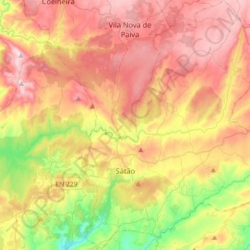
Name: Sátão topographic map, elevation, terrain.
Location: Sátão, Viseu, Viseu Dão-Lafões, Centro, Portugal (40.68107 -7.77551 40.87479 -7.57070)
Average elevation: 2,090 ft
Minimum elevation: 1,109 ft
Maximum elevation: 3,018 ft
Thank you for supporting this site ❤️
Make a donation
Make a donation
Gear up for your next adventure:
As an Amazon Associate, this site earns from qualifying purchases at no extra cost to you.