
Hienheimer Forst topographic map
Interactive map
Click on the map to display elevation.
About this map
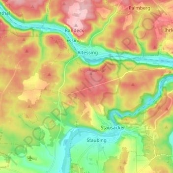
Name: Hienheimer Forst topographic map, elevation, terrain.
Average elevation: 1,398 ft
Minimum elevation: 1,115 ft
Maximum elevation: 1,729 ft
Other topographic maps
Click on a map to view its topography, its elevation and its terrain.
93309
Deutschland > Bayern > Landkreis Kelheim > Kelheim
93309, Kelheim, Landkreis Kelheim, Bayern, Deutschland
Average elevation: 1,329 ft
Großberghofen
Deutschland > Bayern > Landkreis Kelheim > Kelheim
Großberghofen, Kelheim, Landkreis Kelheim, Bayern, 93309, Deutschland
Average elevation: 1,306 ft
Weltenburg
Deutschland > Bayern > Landkreis Kelheim > Kelheim
Weltenburg, Kelheim, Landkreis Kelheim, Bayern, Deutschland
Average elevation: 1,348 ft
Gundelshausen
Deutschland > Bayern > Landkreis Kelheim > Kelheim
Gundelshausen, Kelheim, Landkreis Kelheim, Bayern, Deutschland
Average elevation: 1,253 ft
Lohstadt
Deutschland > Bayern > Landkreis Kelheim > Kelheim > Gundelshausen > Lohstadt
Lohstadt, Gundelshausen, Kelheim, Landkreis Kelheim, Bayern, Deutschland
Average elevation: 1,309 ft
Staubing
Deutschland > Bayern > Landkreis Kelheim > Kelheim
Staubing, Kelheim, Landkreis Kelheim, Bayern, 93343, Deutschland
Average elevation: 1,296 ft