
Truckee topographic map
Click on the map to display elevation.
About this map
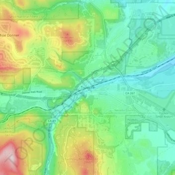
Name: Truckee topographic map, elevation, terrain.
Location: Truckee, Nevada County, California, 96161, United States (39.28796 -120.22325 39.36796 -120.14325)
Average elevation: 6,099 ft
Minimum elevation: 5,689 ft
Maximum elevation: 7,021 ft
Nevada County trails, hiking, mountain biking, running and outdoor activities
Other topographic maps
Click on a map to view its topography, its elevation and its terrain.
Prosser Creek Reservoir
United States > California > Nevada County > Truckee
Average elevation: 5,784 ft