
Make a donation
Gear up for your next adventure:
As an Amazon Associate, this site earns from qualifying purchases at no extra cost to you.
Al Manaqil topographic map
Click on the map to display elevation.
Make a donation
Gear up for your next adventure:
As an Amazon Associate, this site earns from qualifying purchases at no extra cost to you.
About this map
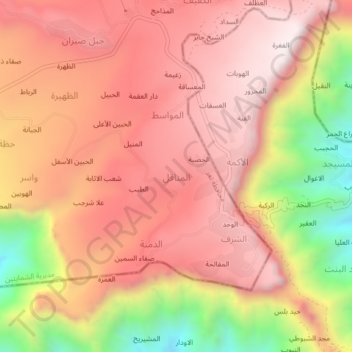
Name: Al Manaqil topographic map, elevation, terrain.
Average elevation: 6,319 ft
Minimum elevation: 4,511 ft
Maximum elevation: 7,339 ft
Make a donation
Gear up for your next adventure:
As an Amazon Associate, this site earns from qualifying purchases at no extra cost to you.
Other topographic maps
Click on a map to view its topography, its elevation and its terrain.
Perim Island
Perim is crab-shaped, 5.63 km (3.50 mi) long and 2.85 km (1.77 mi) wide. It has a surface area of 13 km2 (5.0 sq mi) and rises to an altitude of 65 m (213 ft). Perim encloses a deep and comparatively large natural harbour on the southwestern coast. The fishing village of Mayyun is located at the bottom of the…
Average elevation: 20 ft