
Cilaos topographic map
Interactive map
Click on the map to display elevation.
About this map
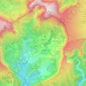
Name: Cilaos topographic map, elevation, terrain.
Location: Cilaos, Saint-Pierre, La Réunion, 97413, France (-21.19499 55.40365 -21.08563 55.50747)
Average elevation: 5,043 ft
Minimum elevation: 1,247 ft
Maximum elevation: 10,046 ft
Other topographic maps
Click on a map to view its topography, its elevation and its terrain.
Piton des Neiges
France > La Réunion > Cilaos
Piton des Neiges, Cilaos, Saint-Benoît, La Réunion, 97413, France
Average elevation: 8,091 ft