
Make a donation
Gear up for your next adventure:
As an Amazon Associate, this site earns from qualifying purchases at no extra cost to you.
Laxe topographic map
Click on the map to display elevation.
Make a donation
Gear up for your next adventure:
As an Amazon Associate, this site earns from qualifying purchases at no extra cost to you.
About this map
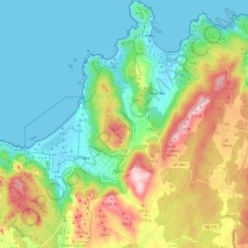
Name: Laxe topographic map, elevation, terrain.
Location: Laxe, Bergantiños, A Coruña, Galicia, Spain (43.15116 -9.07807 43.23345 -8.97226)
Average elevation: 367 ft
Minimum elevation: -3 ft
Maximum elevation: 1,096 ft
Make a donation
Gear up for your next adventure:
As an Amazon Associate, this site earns from qualifying purchases at no extra cost to you.
Other topographic maps
Click on a map to view its topography, its elevation and its terrain.
Praia de Baldaio - As Saíñas
Spain > Galicia > Bergantiños > Carballo > A Pedra do Sal
Average elevation: 43 ft
Make a donation
Gear up for your next adventure:
As an Amazon Associate, this site earns from qualifying purchases at no extra cost to you.